Eben has been to Soyo, on the Angolan side of the Congo River mouth, several times. The extent and size of the river never ceases to amaze him.
The Congo River was made famous in Europe by the old-time explorers such as David Livingstone, and there are many tales about it. The giant river rises in the central African highlands and wanders 4700km to the sea. It is the continent’s second longest river after the Nile.
The source of the Congo is in north-eastern Zambia, between Lake Tanganyika and Lake Malawi, and is initially known as the Chambeshi River.
With its many tributaries, the Congo forms the continent’s largest network of navigable waterways. However, a series of cataracts render it unnavigable between the seaport of Matadi and Kinshasa, as well as on the right bank at Brazzaville.
Although the Livingstone Falls (named after the explorer by Henry Morton) prevent access from the sea, nearly the entire Congo is readily navigable in sections, especially between Kinshasa and Kisangani. Until recently, large steamers worked the river, and the Congo is still is a lifeline in a land with few roads or railways.
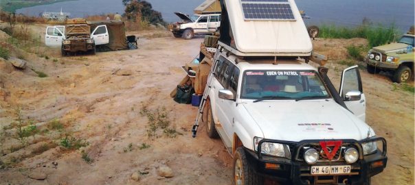
We decided to explore the lower regions of the Congo River, crossing from Angola into the Democratic Republic of Congo (DRC) and the Congo Republic, Brazzaville. We were amazed by the expanse, the magnitude and extent of the river. The areas we explored stretched all the way from Brazzaville, Matadi and right down to the town of Banana (DRC) opposite Soyo (Angola) at the river mouth. At this point the river is more than 12km wide!
We crossed the Congo for the first time at the Noqui and Matadi border crossing. At this point, a bridge has been built and it was with great excitement that we crossed over it. To find big tankers, freighters and container ships some 140km inland from the sea was unreal, and hard to imagine for us “desert dwellers”!
The trip proved to be a true 4×4 adventure since the main routes, both in the DRC and the Brazzaville Congo, are exceptionally bad dirt roads and totally congested by thousands of trucks and minibus taxis.
There is abundant rain, so it is not hard to imagine what these roads look like in summer (muddy, slippery). In winter, however, they are covered with red powdered dust — worse than the extreme dust you would find in the Khowarib Schlucht in Namibia!
The distance between Dolisie and Kinkala, on the way to Brazzaville, is just 280km, but it takes up to 18 hours to complete the journey (not bad for the national N1 road). For the rest, the tar roads (what is left of them) are riddled with potholes.
The good news is that Chinese contractors are working hard to construct new roads on the major routes. On the stretches that have been completed, it is a sheer delight to take a breather and enjoy the beautiful scenery. In a year or two, travelling by road in the region will be a different story altogether.
The most eastern point of the river that we visited was at Brazzaville and Kinshasa, the two capital cities of the two Congos that extend over several kilometres along the opposite banks of the river.