Where did it all start? “Well, digital maps started happening when overland adventurers realised that global positioning devices could also work for them, and pinpoint their location very accurately,” says Tracks4Africa’s Johann Groenewald.
“The first GPS devices were mostly used for marine and aircraft applications, but when recreational GPS’s arrived, the overlanders found it a useful tool. The problem was, however, that the base maps were almost non-existent – not even the cities were mapped properly even ten years ago.
“With the remote areas not mapped, enthusiasts decided to use the GPS unit’s tracking facility as a tool to start mapping these areas. So you would go to Angola, for instance, and on your return download the tracks and waypoints, or ‘raw data’ that you had collected, onto your PC and submit it to Tracks4Africa. This data would then be made available for download on the T4A website and if the next traveller wanted to use it, he needed to upload it to his GPS as tracks and waypoints. In the beginning we had less than a hundred enthusiasts exchanging GPS data and chatting about overland navigation on our forum.”
Navigation software like Fugawe was popular, because it could use raster maps, but then Tracks4Africa stumbled upon software written by a Polish guy that could be used to convert GIS data (we started to configure all raw data in a geographical information system) into a Garmin-compatible GPS map.
“Using the data received from overland travellers, we were then able to build our first base map for Garmin units. It took off. More people realised that the 4×4 community itself was now able to contribute to a GPS map, and it was available for free. This was in 2003.”
In 2005 Tracks4Africa decided to go commercial, as the upkeep and data management were starting to cost money. An article about the venture appeared in a 4×4 magazine, and almost overnight forum membership doubled from 700 to 1400 enthusiasts.
“Some fell by the wayside, but the data kept pouring in, and maintaining it became a full-time job for Tracks4Africa’s Wouter Brand, who’s been involved since the beginning.
“The data was processed using technologies like GIS and systems engineering principles for configuration management. From the start we moved away from traditional map making, focussing on navigation, or rather the requirements of our community. To know where you are is only half the story – you must also know where you are in relation to features like roads and where you should be heading.
The decision to go commercial was tested on the forum, and the vast majority of members were in favour, realising that the value of a map containing everyone’s inserts is far greater than their own personal piece of data.
Also, prices weren’t exorbitant then, and even today an electronic map for say Namibia can be bought for R110.
In 2006 there was a stroke of luck when a National Geographic project on Africa featured Tracks4Africa, and this lead to the data being made available on Google Earth. That opened up a whole new dimension.
And the road ahead?
“To supply travel information for Africa. The truth is that we’re not really creators of maps in the traditional sense. What we do is to capture and present the experiences of the travelling community in an orderly form. But yes, that does require a map.”
“Last year we started the website “padkos.co.za”, as a landing page for every point of interest on our maps. For instance, if you look up North Gate in Botswana’s Moremi Reserve, you’ll find a description, photographs and comments added by the community, and the basic information you need to make it easier to plan a trip.
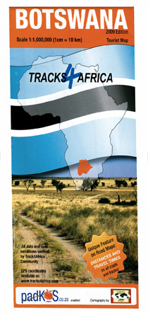
“The next step is paper maps, because people like to have something to put on the table or bonnet for everyone to look at. You can’t gather around a GPS. We’ve just published our first one, Botswana, and all the roads and tracks on there come from our own data. That means if a track is on the map, you will find it on the GPS.”
Data is still pouring in, also from European or American visitors to Africa, as well as South African expats working in other countries. Thanks to the Tracks4Africa community, you can travel from Cape Town to Cairo using only electronic maps.
Another advantage of using data received from actual GPS recordings, is that the average speeds are also available – so the T4A maps (even the paper map) don’t only say how far it is to the next destination, but also how long it will take you to get there.
So, while 40km sounds like an hour’s trip, the road might be so bad that you need a full day – invaluable for planning. The devil’s in the detail, as the saying goes.
“We wouldn’t have been able to do it without the 4×4 travelling community. They’re our biggest assets. We also find that the quality of the data received is getting better and better – some people would actually make a study of a national park to send to us,” says Johann.
“You’d be surprised how willing people are to share information without wanting anything in return, maybe only a little acknowledgement and the fact that the T4A GPS map addresses their specific requirement for navigation.
“For this reason we as the directors of the company also have to act responsibly when managing the data. For instance, we make our data available under a free-of-charge licence agreement to bona fide conservation or humanitarian relief organisations doing good work in Africa.”
“Padkos” or “food for the road” is an apt name for the website, where the traveller can look for titbits of information – how are road works progressing, how thick is the sand on the road to Khutse, what’s the best accommodation in Kang? This is a community-driven project, and the only way it can work is for the community to take ownership of this data, just like they have done with the T4A GPS maps, says Johann.
There are over 70 000 points of interest on Padkos, over 4000 photographs and around 5500 accommodation listings in Africa have full contact details and descriptions added – all thanks to the travelling community. This data is also available in Google Earth under the Gallery folder as a unique Tracks4Africa layer.
“That’s where I see it going,” says Johann. “You have Google Earth as the universal site, you have Mapsource on your computer and the same maps on your GPS, and you have a paper map. All of these have the same underlying data that ties things together – what you see on the map is what you see on the GPS is what you see on Google Earth is what the forums discuss.
“The only thing missing is a more detailed travel guide. And who knows – it might be a logical next step.”
A new venture is MAPA – Mapping Africa’s Protected Areas – a non-profit project to which Tracks4Africa contributes by providing data supplied by its contributing community, as well as its data-processing capabilities.
Having all the data available creates more opportunities – GPS-activated digital tour guides telling tourists more about the places they’re passing by when driving, comprehensive road alerts for drivers, for instance warnings on minor roads when tar becomes sand, or of a cattle grid ahead, or speed alerts for overseas tourists in hired cars. Some might already be available later this year on the Tracks4Africa CD.
The T4A GPS maps are available at the Tracks4Africa website – www.tracks4africa.co.za, and on CD. Maps are Garmin compatible and you require Mapsource on your PC. Selected maps are also available in HandyMap format. The printed Botswana tourist map can be bought at Outdoor Warehouse outlets. Price is R130.
The future? The only limit is your own imagination, it seems…
* Visit www.tracks4africa.co.za or www.padkos.co.za