For many moons, Johan Badenhorst and his Voetspore team have relied on their trusty GPS units, loaded with the latest maps. Now those trusty GPS systems are being replaced by modern smartphones, loaded with the latest maps. Is the end of the traditional GPS unit nigh?
Ever since we left Cape Cross in March 2000 until recently, every step of our journeys has been planned, mapped and recorded on a GPS. In the recent past, I have written quite a bit in our monthly Voetspore diary about these navigation tools. I see this as just as much a part of a safari as Old Man Emu suspension, winch, long-range fuel tank and all-terrain tyres. Yet now, after completing the Indian Expedition, I believe that we are witnessing the death of the GPS as we know it. Over the last few decades, we have experienced tremendous development in the field of electronics. We have witnessed the development of fax machines, PCs, cellphones and the GPS. Pocket-sized electronics are not science fiction anymore. Today it is science fact. It is claimed that the average household washing machine of today involves more electronics than what was on board the Apollo 11 shuttle that made the moon landing on 20 July 1969.
The Global Positioning System (GPS) was developed by the United States Military. A minimum of 24 satellites are placed in orbit. They allow a GPS device to communicate with them and calculate the device’s geographical position. In the 1980s, this technology was made available for civilian use. In Russia, a similar system, the Russian Global Navigation Satellite System (GLONASS), was developed. This, too, is available for civilian use. Commercial companies, such as Garmin, TomTom and Magellan, exploited the technology and refined it to the extent that no one making use of the system, had any doubt of exactly where they are, anywhere on the globe. The system was made even more user-friendly. Detail was added. Fuel stations, ATMs, restaurants, geographical points of interest… all became part of the information displayed on the device. Navigation software was introduced. The GPS became a sophisticated electronic map, not only showing you where you are, but also how to get from A to B, and to C, D, E and F. Distances were measured and estimated times of arrival calculated. It became an essential navigation tool.
In South Africa, Wouter Brand realised that there was a special application for the GPS device. Many South Africans, or people travelling the continent, do so on unexplored terrain. The number of people visiting the fountains of Gai-Ais in Namibia annually are only a handful, compared to the thousands that visit the Mugg and Bean in Woodlands, Pretoria. Yet for these travellers, the true information about tracks in Damaraland can be a matter of life and death. So the Tracks4Africa community was created with members of the public sending their tracks to T4A headquarters. All these tracks were then compared and combined and updated on a regular basis. Southern Africa, and later the rest of the continent, was mapped by ordinary travellers. No GPS track was more real than the T4A track.But then things changed. In the early 2000s, two Danish inventors, Lars and Jens Eilstrup Rasmussen, developed a mapping system which was acquired by Google in 2004 and in 2005 launched as an app called Google Maps. This replaced the GPS device as navigation and was now available on your smartphone.
Yet this aid has one serious shortcoming. It is dependent on cellphone signal. Therefore, especially in off-road conditions, the GPS device still had the edge. The GPS devices and the maps are expensive items, but in safari conditions – somewhere in the Namib Desert, the Kalahari in Botswana, Northern Mozambique, even in the deep forest of the DRC – money is not an issue when it comes to navigating through inhospitable terrain. In places like these, the brilliant invention of the Rasmussen brothers is of no use. There has been another recent development in GPS mapping, namely the appearance of free GPS data. One such map is maps.me. These do not depend on triangulation or cellphone technology. Only a GPS signal, in other words a clear view of the sky, is needed. These maps, which are downloadable in regions as not to clog your device with too much information, are amazingly accurate with detailed data, at no cost.
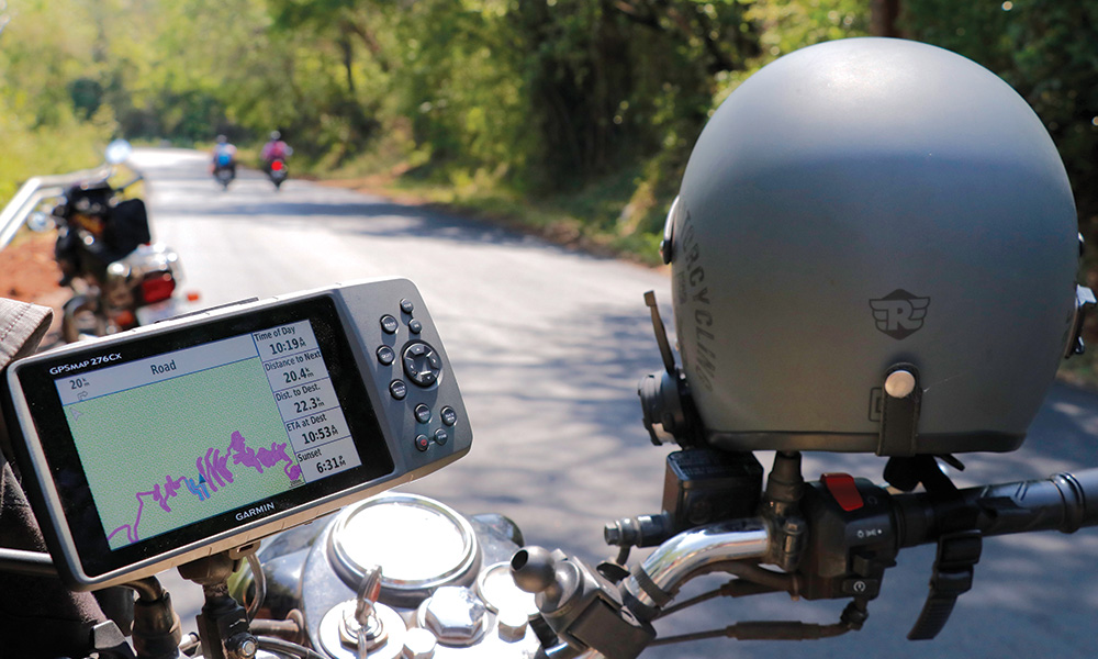
On our recent trip through India, we made use of a number of devices. Streicher had his iPhone. So did Stefan. Simon used an Android phone. I used the real thing – a Garmin 276Cx. A proper GPS with the most recent maps of India as Garmin could provide. On a previous visit to India, I noticed that all taxi and Uber drivers rely completely on Google Maps. I spent all my time during that visit in urban areas where massive cellphone networks support the more than 1.2 billion people. I knew that in the cities, and in all other areas where there is cellphone signal, the Google option was probably the best. But I also knew that we planned to go to Sikkim and Leh/Ladakh. I knew that often we would travel in areas where, even in India, there is a serious lack of cellular communication. That is why my choice fell on an old favourite, the 276C. Navigation requires information of a number of variables. Just having the map and the route is not enough.
Road conditions may change. Weather may play a role. In urban areas, information on traffic congestion is essential in planning a journey. This is where the classic GPS has serious shortcomings. TomTom, had for some time, the edge in addressing these issues when ‘live traffic’ was introduced and the navigation device took this information into consideration when routing. The TomTom device had to have its own SIM card, or be connected through a normal cellphone with data capability via Bluetooth. This did imply however, separate devices. All systems therefore had shortcomings: the Garmin had information that was true, but dated; Google Maps needed cellphone signal; the TomTom offered the best of both and where there was cellphone signal, the maps would be updated. Where there was none, it fell back on existing information.
On our Indian Expedition, we relied almost 100% on Google Maps. The data was accurate and up to date. Rerouting was always to our benefit. When we ran out of cellphone signal, like in the politically sensitive Jammu Kashmir where the Indian government limits the use of communication to the extent that our international roaming was totally ineffective on our cellphones, we relied on maps.me. My 276C, as reliable as it is, was seldom put to use. Not only are the maps dated, but routing with this Gamin will sometimes take you to weird and wonderful places; places that you did not necessarily plan to visit. There is always confusion between shortest distance and quickest route when it comes to routing. There is another serious problem with the Garmin: it does not have the predictive text option. One has to spell the name of a destination letter by letter. Make one mistake, and you have to re-enter the name. It is as though you are working with middle aged technology in the 21st century.
The GPS devices are expensive. The new 276C costs more than R12 000. Add to that the maps of India for another R800. The data for usage on the cellphone is not for free either. I paid 600 rupees, which is less than R130 for one gig of data per day for three months on a Jio device. Some of the other guys had more expensive packages specifically for their cellphones, yet over a period of three months, for the navigation option, plus downloading your emails, communication with WhatsApp and surfing the net, the expense was negligible. Will I condemn my Garmin or TomTom to the rubbish bin? Not quite yet. Last time I checked I noticed cellphone towers only at Epupa and Purros in Kaokoland. When navigating Van Zyl’s Pass, the Marienfluss and many parts of Kaokoland and Damaraland, the trusted option remains a proper GPS loaded with a T4A map. For now. Change I believe, is imminent.
Text and images: Johan Badenhorst