Since both Glyn Demmer and Johan Badenhorst have dedicated their columns in the November issue of Leisure Wheels to GPS navigation, I thought it a good opportunity to discuss how my own navigation habits have changed over the last couple of months.
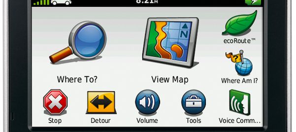
Until fairly recently, I have always made use of a Garmin Nuvi 500 unit. With both Garmap’s Sub-Saharan Streetmaps and the latest Tracks4Africa mapsets always installed, I usually found what I was looking for without too much hassle. If Garmap didn’t have detailed information on an area, I could invariably find it on Tracks 4Africa, and vice versa.
Lately, though, my Nuvi has been relegated to the back of my closet, rarely given an opportunity to see the light of day. The fact of the matter is, it has become obsolete. I simply don’t have a use for it any longer. How so? Well, my Samsung Galaxy S3 cellphone has taken over navigation duties completely.
With both free and paid-for navigation apps available for modern smartphones, I see little need for a dedicated GPS unit.
If you’re travelling around cities or large towns, where you are likely to have a 3G data connection for your phone, a free application such as Google Maps is really all you need since it provides reliable turn-by-turn navigation.
Another great free app is Waze, which Google recently purchased for $1-billion. It is a community-driven app that allows you to notify other users of things such as accident scenes, speed cameras, construction areas or other traffic-related issues.
In my experience, Waze doesn’t provide the best turn-by-turn routing (if you don’t have some idea of where you are going, you could get lost), but it isn’t really designed to provide navigation to a location you are unfamiliar with. Rather, it is designed to assist you with your daily commute, alerting you to traffic problems and showing you alternative routes. With just a quick glance at the map, you can see where traffic is moving well below the speed limit.
Of course, the problem with these free apps is their dependence on a data connection. Since the map isn’t downloaded onto your phone completely, the data needs to be downloaded continuously, so once you leave built-up areas where there is a data connection, your phone will stop supplying the map.
Luckily, though, TomTom has released a reliable app that downloads the map onto your phone, meaning you don’t need any phone signal to use it. You only need to have your phone’s GPS activated. The app is pricey (R664,97), but you get free map updates for as long as you use the app. The application is also continually being refined. Until recently, you couldn’t set a destination by entering its co-ordinates, but an update has sorted out this silly oversight.
But what, you may ask, about bundu travel? Surely a smartphone is useless when you’re travelling in the middle of nowhere?
Until recently, this might have been true, but Tracks4Africa is now available both for Apple and Android. So, if you have an iPhone, iPad or Android device, you can install the Tracks4Africa app and use it when overlanding.
As with the TomTom app, the mapset is downloaded onto your phone completely, so no data connection is needed once the app has been installed.
While Tracks4Africa provides the mapset, the actual navigation application has been created by NNG, makers of the iGO software. I have been using the app for a while now, and have to say that I am very happy with it. It is easy to use, and seems very stable.
I suppose that some overlanders will still feel the need for a dedicated GPS unit, especially those who want advanced features such as being able to leave breadcrumbs (if you want a GPS tracking app, by the way, check out Google’s MyTracks). But I don’t think it will be long before a smartphone can do absolutely everything a GPS unit can do.
The Tracks4Africa app retails for R750. For more information, visit www.tracks4africa.co.za. Google Maps, Waze and the TomTom Southern Africa app can be found in the Google Play store.