We all use maps at some point or another. Even with the advent of GPS, paper maps can’t be entirely replaced. Yet. But where do maps come from? What actually goes into producing a high-quality map-book? And where is it all heading for in future? We spoke to George Borragerio from Geographic Maps to find out
Text: Danie Botha
How did they do it?
We’ve oft en asked ourselves this question when traversing a road in the gammadoelas that seems to lead nowhere. Yet this very road is on our map, or displayed on the GPS system. Do they use satellite technology to map an area? Planes? Does someone actually drive all the roads?
All of the above is actually correct, says George Borragerio from Geographic Maps.
But before we get to the “how to” part, first a bit about the man himself and how he turned a passion into a lucrative business.
Eighteen years ago Borragerio was a successful property developer making enough money to keep most businessmen quite content. But not George.
“I was gett ng increasingly ti red of the stresses and deadlines associated with the property business and I was yearning to do something I had a real passion for, something that I actually would enjoy doing. One day I walked into a book store, looking for a map. After inspecting what was available for sale I realised I may have found that passion – and a huge gap for a competitive player in that market. I’ve always loved geography, and working in this industry would allow me to head out to new horizons, exploring,” says Borragerio.
So he started doing research, and soon found the first link: comprehensive aerial photography, the base of any map. He started playing around on a computer too, with mapping soft ware. He focused his attentions on the Bedfordview area, and drove and documented every street in the area.
“Partly due to the limited computer technology of the early Nineties, and partly because I was learning as I went along, it took me eight months to build that map,” explains George. “I befriended a city planner in that ti me too, and he showed me a few tricks of the trade, which helped a lot. Soon enough we had three map-books on the shelves: Bloemfontein, Pretoria and, of course, Bedfordview.”
The Pretoria map-book sold out in 60 days.
Then George came up with a master stroke.
“There were existing map-books of the Witwatersrand, Vaal Triangle and Pretoria, but I decided to put the three together in one publication called “Greater Gauteng”. We also added important landmarks to the maps by driving every single road,” says George.
Since this publication hit the shelves, hundreds of thousands have been sold. Geographic Maps soon started expanding its services to other provinces and other countries.
Mpumalanga, Botswana, Namibia, Mozambique… they have all since hit newsstands, with the added benefit of listing important landmarks be it recreational, safety, health or food related.
Geographic Maps’ next big thing is a specialised tourist map for Gauteng, especially with the FIFA Soccer World Cup finals in mind.
“This map book will retail for about R80, and will have everything any tourist, either local or international, will require. It includes everything from locations of speed cameras, golf courses, quad-biking tracks, GPS waypoints, shops, police stations to game reserves. There will even be contact details for said police stations, lodges, restaurants – all the numbers one needs. It will have it all, and it will available soon,” says George.
In theory, then…
Okay, but let’s take this “map-building” exercise back to the beginning. The whole process, from the very start to the finished product that lands up on a shelf in a shop.
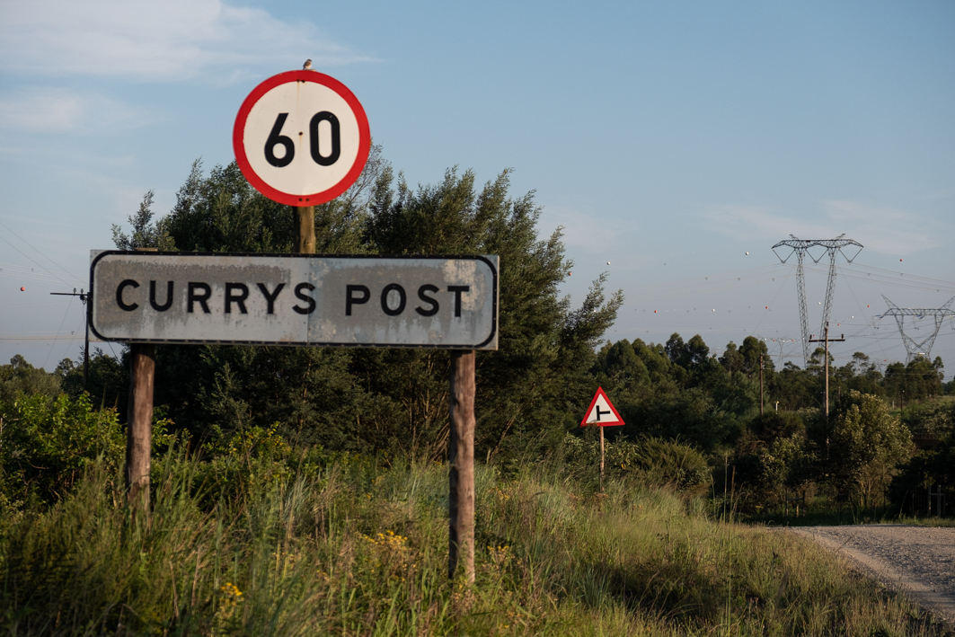
“It begins with an aerial photograph of a specifi c area. The image(s) are digiti sed, and nowadays there is a lot of soft ware on the market for building maps. A specialist then draws a map using the aerial photos as reference, fi lling in the roads, streets, rivers, and so on. Next up is the road crew. The team consist of two people. The fi rst one drives and uses a dictaphone to log all informati on such as fi lling stati ons, police stati ons, street names, whatever,” explains Borragerio.
“The second person uses a map and notebook, as well as a GPS receiver. A note is made of each place of interest, along with the GPS waypoint. This location is also saved on the GPS system. When the crew gets back to the office the GPS is connected to the computer and the track log is downloaded. This is then combined with the existing electronic map of the specific area. Using the dictaphone information, the notes and the track log the map is then built electronically, on the computer, and all the elements are added together.”
To correlate the data, each and every road is covered twice and all the information double-checked.
Finally, when the maps are finished being built, the map-book is prepared for the printing process. This includes proofreading, lay-out and design. Finally, the completed product is delivered electronically to the printers. Once printed, Borragerio and his team of reps distribute the books to relevant shops.
The same principles apply to Global Positioning System (GPS) soft ware, with the difference being that the finished map is loaded electronically onto a GPS unit, via a memory card.
In the future…
Technology waits for no man, and with navigational technologies such as GPS units becoming as common as minibus taxis, what does the future hold for maps?
“What is the first thing you do when you decide you are going on holiday to Namibia?” asks Borragerio.
“Go and look for that map of Namibia,” he answers his own question.
And it’s true.
“The point of reference a map provides is still irreplaceable,” explains George. “GPS is wonderful, but it is also limited to the available data provided by the company.
Some are better than others, but rural areas are mostly still unchartered. We have had a few instances where one of our map clients has phoned us in distress. We gave a GPS waypoint for a specific place on our map, but the client’s GPS could only navigate him to the nearest main road. So any GPS is only as good as the data it is loaded with.”
George had been dabbling in GPS even before the boom-ti me of the Garmins and TomToms of this world.
“I bought one of the very first GPS units available on sale here, a Magellan unit, and started adding GPS waypoints to our maps. So we’ve been at it for many years already,” he says.
But he also fully realises the value of those electronic gadgets that live on cars’ windscreens.
“Currently the biggest limiting factor when it comes to GPS is cost. The cheapest units still retail for over R1000. That’s why I’m in negotiations with a Chinese company to bring in GPS units that will retail for around R600, and will be loaded with our comprehensive database,” says George.
Meanwhile the GPS industry itself is facing a new challenge, says George.
“Cellphones with built-in navigation are becoming more readily available, and bett er too.
So technology is certainly moving right along.”
And how about 20 years from now? Will paper maps still exist?
“I think there will always be a market for a paper map, be it one that lives on the wall or one that is used solely as a point of reference at home. The next generation maps may be electronic, similar to the new electronic newspaper mediums that have recently hit the international market. You simply buy the maps you need and load them onto the wireless tablet device, and you’ve got a map. But this technology is still brand new and very expensive. It will be many years before it becomes readily available and affordable.”
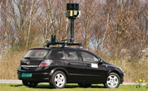
But the next big thing, says Borragerio, may be Google Maps and its Street View technology. This is the next step since the impressive Google Earth navigational and informational technology appeared and became commonly used the world over.
With Street View you can now go to certain “mapped” cities in the world, and literally take a 3D “walk” down the street, on street level. Or download it onto your cellphone. Indeed, you are now able to add a visual, 360-degree image with the destination you are being navigated too.
Fancy a beer in London, but don’t want to land up at some dingy establishment? Use Street View to check out the pubs first. Ditto with any other building or establishment, park, residential address, you name it.
This technology is still relatively new, and it will take many years before every street and road is covered. The equipment used to film the streets (a series of stills cameras) is also very expensive, for now.
“It is really exciting technology. Who would have thought, just ten years ago, that you’d now be able to “walk” down a street by looking at your computer screen or cellphone, with a 3D image of the actual street?” asks Borragerio, rhetorically.
In the car…
Okay, so back to a more tangible subject: the cars you use to drive every single road on your maps, twice. What have you used over the past 18 years?
“I used a Land Rover Defender 90 for a time, but although I couldn’t really fault it, it was tiresome to drive on the long distances we cover. It was fine once we got to those rough back roads, but to get to those back roads was not so great. We needed something more comfortable.
“We invested in several Suzuki Grand Vitaras, and I still have one of them today. It has now covered more than 600 000km, and the only work I have had to do on it was to replace a water hose. The Suzukis were wonderful,” says George.
But when Suzuki was no longer officially sold here, George had to look for something new. He found this in a Mercedes-Benz ML270 CDI – another vehicle he still owns today.
“We used the Merc to travel Namibia from top to bottom, on every road, and it was extremely comfortable. We crossed rivers with it, and it handled everything we threw at it. Meanwhile I also bought a Mitsubishi Pajero 3.2 Di-D, as I needed something more 4×4-ish to cover Lesotho with. Unfortunately the suspension broke after we hit a donga in the mountains. It also proved to be unexpectedly heavy on diesel, so I flogged it soon after,” George says.
Then he bought his most favourite of favourite 4x4s by far: a Subaru Forester 2.5XT.
“The Subaru is unbelievable!” Borragerio says. “Its turbo engine has all the grunt you need, it’s extremely comfortable over longer distances, and it can even do a limited amount of 4×4 work, even though it doesn’t have low-range. This is by far the best vehicle we’ve had so far.”
Aft er driving literally millions of kilometres to map Southern Africa, George must surely have a few tips for motorists who intend heading overland, be it on scenic routes or going the full 4×4 hog?
“My advice would be to buy a soft -roader, honestly. If you plan on travelling 90% of the ti me on tar and dirt, and spend only 10% of the ti me doing heavy 4×4 work, then buy a soft – roader and an older, cheaper 4×4 with lowrange to go and play with. One you won’t mind scratching. For the rest, a modern soft -roader such as the Forester offers a comfortable and practical on-road ride, be it tar or dirt, and most can handle a bit of off -road too, if they have to,” concludes Borragerio.