While our families were enjoying five-course Christmas feasts, Viaane and I lunched at Nandos in Kokstad. At least we did not have to wait for service, and we also had the roads to ourselves.
We filled up the vehicle’s tank (80 litres), two 20-litre jerrycans and a 25-litre plastic jerrycan at Matatiele before proceeding on our Lesotho adventure.
Exactly 313km from the Mariannhill toll plaza, we reached the gravel road leading to Ramatseliso’s border post, 42km away. Our average speed was 50 km/h, because any faster would have created unnecessary dust for the locals whose houses border the road, and for those parading about in their Christmas outfits.
27km farther on we started ascending into the mountains. The road condition deteriorated and we had to reduce our speed to just 20 km/h. The time was 3.05pm and I started worrying about reaching the border post in time. The road deteriorated and, to make matters worse, I started smelling petrol.
I noticed that petrol was leaking from the lid of the plastic jerrycan. Serves me right for not testing it prior to the trip, I thought. The border post, which closed at 4pm, was still about 12km of rough terrain driving away and we had less than 40 minutes to do it in.
We reached Ramatseliso’s gate at 3.55pm, stressed out and stinking of petrol. There wasn’t any border post on the Lesotho side, so we were stamped out of SA but not stamped into Lesotho. Confusing!
The gravel road from the border post to the Sehlabathebe National Park was decent and we drove through a number of villages where we were greeted with friendly waves and continuous requests for sweets by the local kids.
We arrived at the park, only to be informed that the lodge was fully booked, but we could erect our tent wherever we wished. We were asked if our tent was “strong”, because of the windy conditions they experienced at night.
Just our luck that all the sites among the trees were occupied.
Unpacking the tent, I discovered that the tent ropes had been left behind. Darkness was setting in and the wind had started to pick up.
Day one lessons learned:
* Test equipment before leaving home
* Double-check packed equipment
* Allow for unforeseen circumstances
Day 2
Sehlabathebe National Park.
We awoke to the chirps of the resident birds and in full view of the rising sun reflected off the “Three Bushmen” in the distance. In spite of a windy night, our tent stayed grounded (thanks to some spare rope kept in the bakkie).
All the animals from the nearby pond came alive during the night. I never knew that frogs could be so loud. We also heard ducks, crickets and a “knocking” sound that I could not identify. At 2am we heard a jackal cry not too far away. A wonderful experience indeed.
We took a guided hike of the immediate area with the chief ranger – Bernard Penane. He introduced us to the history of the park, took us to where the rare Sehlabathebe lily grows and showed us the many natural sandstone arches of the region.
He also explained the problems that he and his team experience in the park, like drug trafficking, and graffiti on the cave walls left by tourists. His cost for half the day was a mere R50.
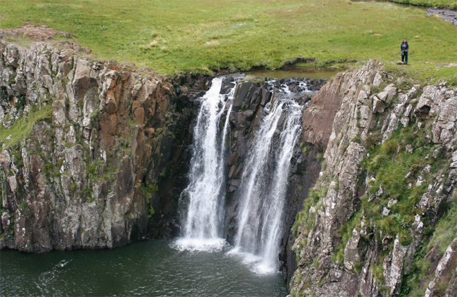
After lunch, with dark heavy clouds moving in over the escarpment, Viaane and I left for a two-hour return hike to the Tsoelike Falls. (This can also be done on horseback). The falls were spectacular. We returned to a misty camp, wet, shivering and thankful that the lightning that accompanied us on our return walk did not decide to put an electrifying end to our existence. Walking in the mountains with lightning dancing all around you is an experience that is not easily forgotten.
We retired early that night, more appreciative of the gift of life.
Day 3
The rain delayed our departure from 7am to 9am the following morning. I figured that even at 30 km/h we should still be able to cover the 130km to Katse Dam before sunset. I could not have been more wrong.
Of all the passes we drove through that day, the Matebeng Pass was the most spectacular. It twists and turns before descending down the other side passing through a number of small villages. Later on that day we realised why Lesotho is called the Mountain Kingdom: You have to negotiate one mountain pass after another.
We crossed the Senqu River and proceeded up another mountain pass with great views of the Senqu to our left. In some places the terrain was steep and rocky, and I imagine treacherous when wet.
Whenever we passed through a village the kids would run up to the van and ask for sweets and money.
We finally reached the Sehonghong Pass later on in the afternoon, 69km later, and not the 42km as stipulated on InfoMap. We were lucky to find accommodation at the Mashai Lodge, after 80km and five hours of travelling (not including lunch and photo stops). Once again the Tracks4Africa GPS maps impressed, but we lost all faith in the InfoMap.
Day 4
When I opened the lodge door in the morning I was greeted by a cold wind. It rained most of that day. My thoughts then were if the road condition was like that yesterday in the dry, then we were in trouble. I got soaked while packing the van.
The road from Mashai to Katse Dam was actually in good condition. The first 25km of driving was done on a wet and slippery road and we needed to be cautious on the bends, especially on the passes. There were puddles of water on the inner bends and a long drop-off on the outer bend. On two occasions we met approaching vehicles on our side of the road.
There were signs of road maintenance throughout. The road is tarred at Thaba Tseka, but is gravel again when you take the turn-off to Katse. Thaba Tseka did not have any fuel when we drove through.
The view of the Katse Dam wall was breathtaking. We just stood there, not saying a word, astonished by this great engineering feat before us. At that moment all the effort required for this trip became worthwhile. Pictures cannot justify this view, and you have to see it for yourself.
We spent the night at the Orion Katse Lodge. The Orion Group took over the management of the lodge a year ago, and also manage a few two- and three-bedroom houses in the vicinity. On arrival they inform you that they accept only cash, but after a few ifs, buts and maybes they were willing to accept a card. The closest bank is at Thaba Tseka.
Day 5
We departed Katse at 8am with the intention of driving a 4×4 route between Seshote and Mapholaneng. This route is not recorded on T4Africa, but is shown on the AA map of Lesotho and confirmed by the locals.
At the top of the Nkaobee Pass we found a fuel stop where both petrol and diesel was available. They are open from 8am to 6pm.
Between Katse and Seshote, due to the rain and resultant landslides, there were plenty of rocks on the road. I will carry a four-pound hammer and chisel on future trips to this area, because some of the rocks were too huge to remove. One could then put a chisel to the tiny cracks.
We turned right at Seshote and were back on gravel. Approx 7km farther on, the wet, muddy road played havoc with our progress. We spent more time driving sideways as the bakkie slid around on the muddy surface than we did going straight. The tyres were caked with mud. And according to the locals the most difficult section was still ahead. Thoughts of sliding off a mountain pass motivated us to return to the main road.
We then decided that we would take a right turn at Lejone to follow the 4×4 route through Kao and towards Tlaeeng Pass. Approximately 18km from the tar road this route winds down to cross the Malibamatso River.
Another dead end. There was no way that we would attempt to cross such a flooded river. Our only safe option was to return to the tar road at Lejone.
From Lejone we took the tar road to Pitseng, turned right at Hlotse and carried on through Butha-Buthe, passing the many spectacular mountain passes. The road between the New Oxbow Lodge and Mokhotlong has the worst potholes that I have ever seen.
When we reached the Letseng diamond mines we noticed a board advertising Maloraneng Chalets, 9km away, which were accessible only by 4×4. Because it was getting dark, we decided to spend the night. The drive down to the chalets was on a steep and rocky track that crossed numerous mountain streams.
Reaching the chalets, we were surprised to discover such a gem hidden in the Maloraneng Valley. These chalets were by far the most beautiful and comfortable accommodation that we experienced on our Lesotho trip.
Day 6
We awoke on our final Lesotho morning with mixed feelings. We were sad that our trip was nearly over. We consoled ourselves with a promise that we would return to Lesotho soon.
We had coffee with Anna, the friendly, laugh-a-minute lady who is in charge of the Maloraneng Chalets, discussing life in general. One of her dreams is to see the sea.
The drive to Sani Pass, from the turn-off on the outskirts of Mokhotlong, was on a good gravel road. The state of the road for approx 1km from the top of Sani Pass (steepest secti on) is the worst that I have ever seen it, and seems to be deteriorating rapidly. But due to the large amount of traffic that we saw on our descent, I can understand why.
Our Lesotho visit was an eye opener. It made us realise how fortunate we are and to appreciate the simple things in life. We will definitely be back.