MapStudio recently released a travel book by Patrick Cruywagen titled Your Bucket List, which gives detailed descriptions of 150 adrenaline-pumping must-do experiences in southern Africa. Below is an extract from the book, highlighting five 4×4-related adventures.
DRIVE THE LONGEST UNINTERRUPTED GRAVEL ROAD IN SOUTH AFRICA
When: All year round
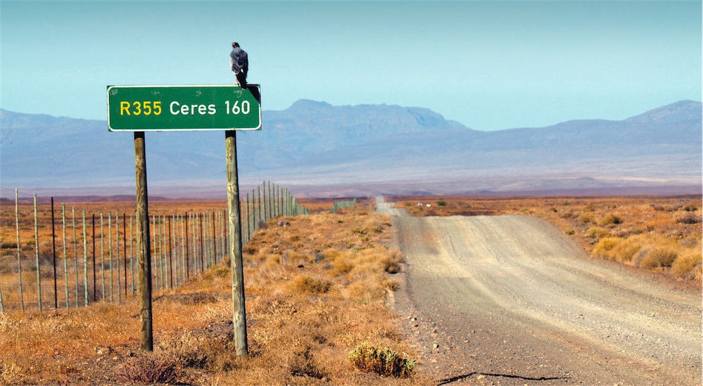
Where: Between Ceres and Calvinia, Western Cape
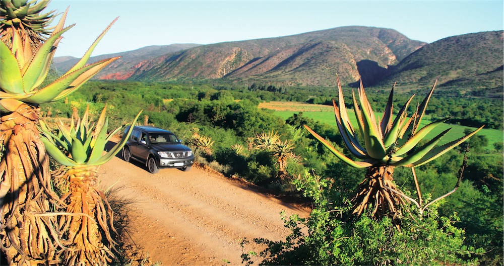
This is the longest uninterrupted gravel road in South Africa, and everybody has to drive it at least once. It is 257km long, starts at Ceres in the Western Cape and finishes in Calvinia in the Northern Cape province.
This would be a good time to clarify something: you don’t just drive this gravel road because of its record-breaking status, but rather because of the adventures and opportunities that lie between these two towns. You might actually want to take a detour or two along the way. Before you set off, you need to make sure that all your tyres are in good condition; also take with you all the necessary gear to change or repair a tyre, as there’s a good chance you might get a puncture or two. Remember that you are about to do almost 260km without refuelling, so you might want to fill up before you tackle this gravel road.
When you hit the gravel for the first time, take it easy and drive within your capabilities. This road has seen many an accident and flat tyre, so don’t become another victim as you run out of talent on a seemingly gentle road curve. The gravel can be deceptively slippery and you will need to muster all your driving skills.
After about 103km, you are faced with a dilemma. You could either take the turn-off to the Tankwa Karoo National Park, which is well worth visiting for a day or two. More adventures, an interesting pass and the unique Tankwa Karoo landscape await you there. Alternatively, you could take the confusing network of gravel roads leading towards Sutherland, though you will first have to conquer the Ouberg Pass.
The final option is just to proceed on the R355 and find yourself an overnight stop such as Die Mond, though there is a short little detour to get there.
Die Mond is one of those places where you plan to stay only for the night but then end up staying another night – it is a real oasis of a place.
Before you get to the end of this extremely long gravel road, you will have to negotiate the Bloukrans Pass. You might struggle a little for traction as you reach the top of the pass, so make sure you are in the right gear.
It is worth stopping at the top to take a look at where you have come from. The R355 seems to go on forever as you look back. Not long after this, you will join the tar road (the R27) before arriving at Calvinia.
Reward yourself with a night at the local hotel, where the beers are cold and the meat plentiful. Other than that, there’s no reason not to move on. Well done – you’ve just driven the longest gravel road in South Africa.
THE MATROOSBERG 4×4 TRAIL
When: In winter during a cold snap (see the Matroosberg Facebook page for snow updates)
Where: Just outside Ceres, Western Cape
The Matroosberg 4×4 Trail, just outside the Boland town of Ceres, gives you the best chance of seeing snow in the Western Cape in winter. It’s the highest trail in the area, as it climbs up towards the Matroosberg Peak, which stands at 2,249m. In severe cold snaps, 4×4 enthusiasts monitor the Matroosberg Facebook page for the latest snow updates. When they get the green light, their 4x4s are filled with kids, jackets and flasks, as families head off to have fun in the snow. It’s like being in the Swiss Alps during winter, except that Table Mountain is just two hours away.
There’s only a single track up and down the mountain and no vehicles are allowed onto the trail after 11:00 when there is snow, so allow enough time if you’re coming from Cape Town for the day. Alternatively, make a weekend of it, as there are several accommodation options available at Matroosberg. The 4×4 drive to the snow and the Conical Peak lookout point is 14km and should be attempted only by vehicles with low range and decent ground clearance.
Vehicles such as the BMW X5, Nissan X-Trail and Subaru Forrester are not allowed onto the trail. For the most part, the trail is not technical or extreme, though in dire weather it can become tricky and inexperienced drivers will find it tough going. There are a few sections where you really have to concentrate, so go slowly, choose the right lines and try to get your tyres onto the high points. Many have learnt the value of deflated tyres on this trail, so lower the tyre pressure to 1,2 bar when signing in at reception – this significantly increases capability.
From the outset, you climb pretty steeply to the first test, Land Rover Hill (engage low range here), which can become muddy and slippery during snow and rain. The drive to the top takes about two hours, but thankfully there are a few places to stop and break it up, which is great if you have small kids in tow.
Not far from Land Rover Hill is the first stop, about 45 minutes into the trail: a lookout point called Lakenvlei. Further on, at the Conical Peak lookout, there is another loop you can do, but only in the dry season as snow makes it impassable. Still, this loop is the toughest part of the trail and should be undertaken by experi- enced drivers only, and a diff-lock will help on this extremely rocky section. For those who want more than snow and a mountain drive, there is a 4×4 obstacle course not far from reception.
In the summer, pick cherries on the neighbouring Klondyke Cherry Farm. (Entrance is R15 and you will be charged R45 per kilogram of cherries picked.) But it’s that one four-letter word that has the people coming in their masses: snow.
GO GRAVEL FROM JOBURG TO CAPE TOWN
When: All year round
Where: Between Cape Town and Johannesburg
Most people have had to drive the tar roads between Johannesburg and Cape Town at least once in their lives. Maybe it was to relocate, or to attend a mate’s 21st birthday party – whatever the reason, it is a stressful slog of more than 1000km. I did it in a day once, during a winter break while studying at Stellenbosch University. We left at 04:30 and drove triumphantly into Pretoria over 12 hours later, by which time I needed a very stiff drink. If you have the time, a sense of adventure and a half decent vehicle, why not try doing this drive solely via gravel roads?
I’ve done it, though strictly speaking it is impossible. You have to take the N1 out of Johannesburg, but once you get to Parys you can really have some fun as you head into the real rural South Africa. From Parys, it is possible to go on gravel to Viljoenskroon, Bothaville and on to Hoopstad. A good place to stop here is the Sandveld Nature Reserve that borders the massive Bloemhof Dam, a popular fishing spot.
A good place to overnight is the Kuruman area, where visits to the Kuruman Eye and the Moffat Mission are a must. Take a seat underneath the tree where Moffat’s daughter Mary fell for Dr David Livingstone.
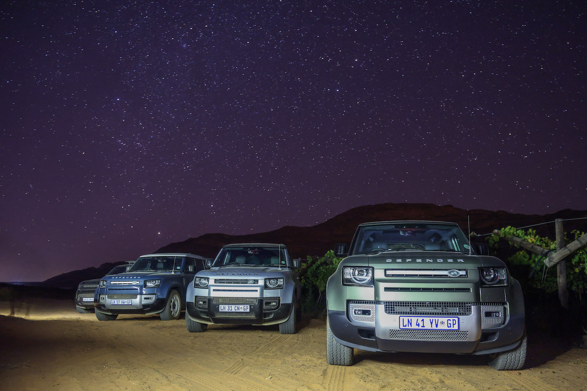
The R385 will take you all along gravel to Prieska, but be warned: when this road is in a bad condition, you will get a serious shak- ing and probably lose a tyre or two. A good idea when doing this trip is to ask locals about the condition of the road, provided they have actually been on it in the past couple of months. From Prieska, it is on to Carnavon, Loxton, Fraserburg and Sutherland. If you have clear skies, spend the night in Sutherland, the stargazing capital of Africa. If not, rather opt for the Cederberg. To get to Ceres, take the scenic Ouberg Pass. Unfortunately, it is impossible to get into Cape Town from here without taking tar.
There is no one definitive gravel route that connects Cape Town and Johannesburg. Road conditions change all the time, and different people like to experience and see different things. It is a real case of trial and error, plotting and planning, getting lost and taking alternative routes.
The one thing this adventure is sure to do is to introduce you to parts of South Africa you will never have seen before, and you are guaranteed to meet some real characters. Take the opportunity to chat to the locals and find out which is the best gravel road to take.
DRIVE THE BATTLEFIELDS ROUTE
When: All year round
Where: KwaZulu-Natal
Some of the most horrific and history-changing battles took place in KwaZulu-Natal as the Boers, British and Zulus fought each other until death, surrender or withdrawal. A proper tour of all the major battlefields takes time, as there are so many of them and they can be rather hard to find. I would recommend using a good guide – there is only so much a book can tell you, and the guide can point out the exact spot of significant events. Another tip is to perhaps focus on a specific war, such as the Anglo-Zulu War or the Anglo-Boer War, to help you understand how the various pieces of the puzzle fit together.
The Battlefields Route runs through the northern section of the province. Below you’ll find a chronological reference to some of the most significant places – though you wouldn’t visit them in this order. The first is the Hill of Execution, which can be found in the eMakhosini Opathe Heritage Park. This hill was where Dingane had Piet Retief and his party murdered after tricking them into leaving their weapons outside. The Boer revenge came quickly and most dramatically only a few months later, at the Battle of Blood River. Here, 468 Boers managed to kill over 3,000 of the over 10,000 advancing Zulus, who unsuccessfully tried to breach the laager formed by the Boers’ ox wagons.
The battle was given this name because the Ncome River turned red from the blood of the Zulus.
Next was the Battle of Isandlwana where, in January of 1879, the Zulus showed how, with the element of surprise, men armed with spears could overrun those with rifles! Twenty thousand Zulus somehow managed to surprise the almost 2,000 Brits camped below the hill of Isandlwana, and only a few hundred British soldiers survived. It was one of the most dramatic losses ever suffered by the British army anywhere in the world, right here below a hill in the KZN province.
The next major campaign of the Anglo-Zulu War was the Battle of Rorke’s Drift, where a mere 150 British soldiers bravely held off over 3,000 Zulu warriors. This was such an astonishing tale of defence against all odds by only a handful of British soldiers that it was made into a movie, entitled Zulu, starring Michael Caine. The battle that changed this war occurred just outside of uLundi, where the British managed to defeat the Zulus, capture their capital and then raze it to the ground. Ten years later the province was at war again – this time it was Boer against Brit in the three-year long Anglo-Boer War.
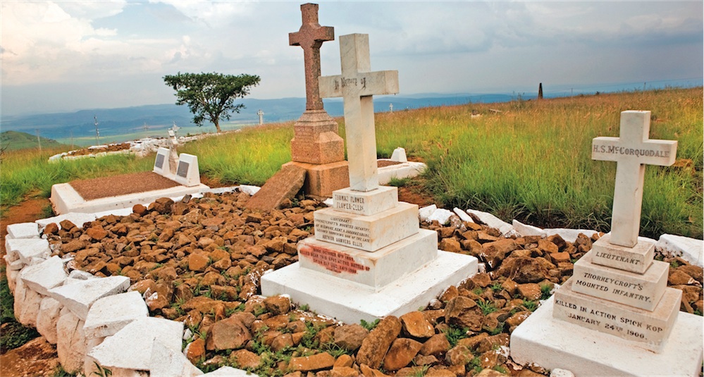
Another good stop on your tour is Spionkop, where the Boers managed to force the British into a retreat, killing almost 400 of them in the process and wounding around 1,300. Many of the dead were buried in the trenches where they fell. Today the museums, trenches and white crosses serve as a stark reminder of one of the many bloody battles that took place in this province. The battlefields of KwaZulu-Natal helped to shape the future of South Africa.
4×4 THROUGH BAVIAANSKLOOF
When: All year round
Where: Eastern Cape
The Baviaanskloof was once a farming hub, but it’s slowly being transformed into a wilderness area, where man and wildlife live in harmony. One thing remains the same – it’s filled with more characters than a Herman Charles Bosman novel. Its natural inaccessibility and scenic surrounds put it high on the list of places to tour in your 4×4, and there is a mountain-bike race that goes through the kloof. This scenic valley runs between Willowmore and Patensie, a distance of just about 200km. To drive it you need a 4×4 and, if
you did it non-stop,
you can expect to
take about five to six
hours. The conditions of the kloof vary greatly. During the rainy season the water crossings are a little deeper than usual and the water damages the road. Fortunately, the farmers in the kloof do try and maintain the road.
You can drive the kloof in any direction and it is wide enough at most places for vehicles to pass each other easily. To drive the kloof in one day would
be criminal, as you will miss out on so much – there are hikes to do, streams to swim in and many accommodation options from which to choose. I have always driven it from west to east, starting in Willowmore. It is only after 44km, when you reach Nuwekloof, that you say goodbye to the Little Karoo and the kloof starts properly. To the north lie the Baviaanskloof mountains and to the south the Kouga mountains. Once past Nuwekloof, you are in the Baviaanskloof Wilderness Area, which has World Heritage status. Farming in the kloof peaked in the 1930s when the populaion swelled to about 3,000. Today the number of people is less than half that. Farmers have been quick to recognise the potential of tourism, and today you can barely drive a kilometre without seeing an accommodation sign. The farmer at Rietrivier has built some very interesting accommodation in caves; he has even supplied elec- tricity. One of the best camp sites has to be Rooihoek, with its white beach sand and crystal-clear water in which to cool off. The kloof has an information centre that is worth a stop if you have not booked a place to stay.
There are many interesting things to see in the kloof. It is the only place in the world where you can see the Willowmore cedar. You can stop at many viewpoints, and Rooihoek is a good place for a swim. On one of my trips we stopped at Bo-Kloof to do a hike into one of the many gorges. There are several signs along the road warning you that there are buffalo about – amazingly there are over 300 bird and 55 animal species in the kloof. The toughest parts of the drive are in the eastern section, though any 4×4 should be able to get through easily enough. The Baviaanskloof is a spectacular drive that should be done as slowly as time allows.
WANT TO ADD MORE TO YOUR BUCKET LIST?
The above five adventures are a mere sampling of what southern Africa has to offer when it comes adventure. For loads more ideas (150, in fact), be sure to pick up a copy of MapStudio’s Your Bucket List.
Price: R250
More info: www.mapstudio.co.za