Our search continues for meteorites, crazy colonisers, rescued reserves and African empires: the Muambe Crater, Massangano Citadel, Gorongosa Reserve and Great Zimbabwe Monument
Part two (of two)
Our route to Njereje village (the “base” for visiting Monte Muambe) had already taken us from Johannesburg through Zimbabwe via Beit Bridge, Harare, Mecumbura, Magoe, Songo, Boroma and Tete into some of the wildest parts of southern Africa.
And yet the overgrown track to Muambe crater’s rim made the rest of our journey look like a stroll through your local shopping mall by comparison.
Make sure that you pick up at least two locals in Njereje to show you the way to the mountain and to clear the trail in the patches where the grass grows higher than “an elephant’s eye”. Ideally do this trip after August when the bush is less dense and to avoid your vehicle becoming covered by a pile of extremely irritating and radiator-clogging grass seed.
Njereje to Monte Muambe is just 10km but with two guides walking ahead swinging pangas it still took us over two hours. So the sun was already changing the cool woodlands around us into a steamy jungle as I pulled on my boots and began the long climb over the rim into the crater area of mysterious Muambe.
Muambe’s forests are considered to be a refuge for the souls of the departed, and my guide enacted a simple ceremony involving burying a small amount of tobacco at the base of a huge leadwood tree before we struggled upwards through razor-sharp elephant grass.
I speak enough Portuguese to be able to ask my companion whether many other visitors had come to the mountain and he said, “Yes, you are the second group this year”.
In fact, since 1992 when a group of geologists from Yugoslavia spent three weeks digging trenches here, it appears that this strange circular arrangement of dolomitic ridges, about 10km in diameter, has attracted close attention from adventurers and scientists from all over the world.
It should have been a two-hour walk to the mouth of the crater, but after three hours of pushing through what appeared to be mini-bamboo, I decided to turn back. My young son, Daniel, was waiting at the Isuzu with the other guide and, anyway, I had already decided on a return trip during the dry season in the near future.
My guide did give me a few rock samples he had collected at the crater and a geologist friend tells me that they are of volcanic origin.
So after all it seems that Muambe is actually an extinct volcano, not a meteorite crater. Makes sense, as this part of Mozambique is on a branch of the Great African Rift Valley – a major tectonic fault line that extends all the way from Egypt to Namibia.
Despite being aware that the Tete and Moatize traffic police are some of the most active with laser or radar trapping guns in Mozambique, we made good time back to Tete. We refuelled (use the 2M station on the main road in town, as the pumps next to the bridge are always busy), and asked about a place to have lunch.
The pump attendant smiled that brilliant Mozambican smile and told us about a restaurant called Paraiso Misterioso and, probably because we looked badly in need of some serious scrubbing, added that it had a “piscina”, or swimming pool.
Paraiso produced excellent chicken piripiri and, believe me, Tete has got to be the best place in the world to spend a searing afternoon sipping cold drinks in a pool. There is a nice guesthouse next door that has air conditioning, and if our tight schedule had been more sensible it would have provided a place to lay our sleepy heads, but my agenda had us crossing the Luenha River near Mandie before sunset.
Note that when coming into Tete the last 10km or so has a speed limit of 60km/h, but if leaving Tete on the same stretch of the Estrada 103 you can drive at 80km/h!
We pulled off at Mazoe village and asked for the way to the Luenha River where, according to my topographical map, there was a likely contender for a river crossing point.
The looks the locals gave us indicated there was no way these barmy “brancos” would even get to the river banks, let alone ford the stream, so I shrugged my overworked shoulders and took the Isuzu onto the 180km “detour” via Changara, Mungari and Mandie to Massangano.
The turn-off to Mungari 54km from Changara is not signposted but quite distinct and we turned down an excellent gravel road, enjoying biscuits and Fanta for supper in Mungari before continuing on under marvellous moonlight down a road that got narrower but strangely smoother the farther we went.
The Isuzu’s dependable diesel motor hummed almost cheerfully as we rolled towards Mandie with giant baobab and mahogany trees glistening in the moonlight. I was reminded why I love these Mozambican back roads so much – they are scenic, there’s no traffic, the surfaces are surprisingly good and people are friendly.
In Mandie, remember to turn right after the Posto de Saude, otherwise you could end up in the Luenha River. From there on it’s a good track that runs close to the river – a truly memorable drive – all the way down to Massangano, where a simple sign, “Fortaleza da Massangano” (our second “Lost City”), announces your arrival at the solitary stronghold.
We camped at the sign but in the morning I noticed that a few hundred metres farther down on the left there is a nice shady clearing on smooth rock overlooking the Zambezi that would have been a better spot.
Massangano’s spectacular setting would probably have attracted a few big golf estate developers by now but for its perfect location at a dead-end in the heart of nowhere.
The strategic qualities of this location were certainly not overlooked by one Joaquim Jose da Cruz, (then known locally as Nhaude, or the “spider-web”), who built the “aringa”, or fortified village, on top of a hill at Massangano in about 1830. The Da Cruz clan gathered the support of local tribes and managed to seriously undermine Portuguese authority throughout central Mozambique.
In response, the Portuguese government mounted nine disastrous military expeditions against Massangano, which was finally abandoned only in 1914. The fortress remains surprisingly intact and the views from the ramparts north over the Zambezi, west over the Luenha and south and east over trackless rift-valley bush are enough to make any wanderer tarry a while.
At either end of the stronghold the artillery positions where Da Cruz must have placed the canons he stole from faraway Quelimane are still clearly evident. So is the ruined mansion where this rumbustious renegade and his descendants must have lived.
Backtracking down the track to the main Changara-Nova Vanduzi road was certainly not boring as the views over the Luenha and the forests of Dauvonga are worthy of many more visits. The mega-potholes on the road between Changara and Guro have thankfully been repaired.
We filled up the Isuzu from our jerrycans (we were getting around 700km to the tank, and the next service station would be in Chimoio) before turning east just after Comacha towards Macossa and Gorongosa. What started as a good gravel road turned quite rough and wet from Macossa to the junction with the new Gorongosa to Caia “highway”.
There are great views of the imposing Monte Gorongosa massif from this area and we found a wonderful bush camp next to a great natural pool in the Nhandungue River. But three puffadders and a green mamba sunning themselves on the rocks nearby were a timely wake-up call regarding the real dangers when roughing it in Africa.
At 400m above sea level, this place was lofty enough to get quite chilly at night, and if you plan to include a climb up the 1800m Monte Gorongosa, be sure to pack that cold-weather gear, especially from June to August when summit temperatures can drop below freezing.
From the Nhandungue River it was just a couple of hours (including a stop at Gorongosa town’s colourful clothing market) on an excellent road to the newly rebuilt Chitengo camp in Parque Nacional de Gorongosa.
Over the years I have seen Chitengo transformed from a land-mine-riddled, bombed-out former HQ of the Renamo rebel movement to a charming and well-managed rest camp with grassy, shady campsites, comfortable three- and five-bed chalets with en-suite bathrooms, a good restaurant and two swimming pools.
We camped under the Natal mahogany trees and I was truly impressed by the energy and competence of the staff that Greg Carr, the American entrepreneur who has dedicated his time and money to rescuing Gorongosa, had gathered together to undertake this huge task.
Recent good news stories out of Gorongosa include the introduction of a herd of tuberculosis-free buffalo from the Kruger National Park last year. Also, in an attempt to reduce slash-and-burn encroachment and poaching, the park began its outreach to neighbouring communities and started a tree-planting programme on Monte Gorongosa.
The staff complement has grown from 100 to more than 500 and visitors increased significantly from fewer than 100 in 2000 to more than 5000 last year.
Unfortunately, due to recent heavy rains, most of the park roads remained swamped and therefore closed to the public and so, after a couple of days of waiting in hope, we reluctantly headed for Zimbabwe, stopping for lunch at Pink Papaya Backpackers in Chimoio.
In the past, Gorongosa national park was open from 1 May to 30 November, but it appears management will now open or close the park subject to when the rains begin and end during any particular year.
The Machipanda/Forbes border post was crowded with people trying to bring bags of maize meal and boxes of cooking oil into Zimbabwe. It was quite a bizarre situation, but I kept my indignation to myself as I know from experience that members of the dreaded CIO (Central Intelligence Organisation) hang around here waiting for someone to insult Robert Mugabe (you can be jailed).
Customs seemed to be the man collecting the R60 fee for the Road Accident Fund, and all the other “taxes” (payable in hard currency) that have been invented by a government desperately short of forex.
Once again I was amazed at how passive everyone was in the queue, and how friendly (but yes, terribly slow) the customs and immigration staff still are.
In Mutare, Ann Bruce gave us her usual home-from-home hospitality and the low-down on the latest farm occupations, ridiculous food prices and increasing scarcity of basics such as eggs, fresh milk and toilet paper.
The next day we took a leisurely drive
The only person getting on with the job at down the escarpment towards Masvingo. Along the road to Birchenough Bridge we saw many touts making the sign of a diamond with their fingers – indicating that some of Marange’s (or perhaps even the Democratic Republic of Congo’s) illicit diamonds were on offer.
Don’t be tempted, as there were also four police roadblocks, one of which was equipped with a portable X-ray machine, between the Marange turn-off and Masvingo.
About 10km before Masvingo, watch out for the unmarked (the signpost is down) turn-off left to Lake Kyle and Great Zimbabwe, which is the very scenic back route (4×4 needed during rain) to the monument, and which by-passes Masvingo if you’re heading south.
This time the sky was cloudless (on our way up it had rained for two days). We were taken around Great Zimbabwe by “CJ”, a trainee teacher from the Midlands Teachers Training College.
This was my sixth visit to the ruins – our third “Lost City”. I still wonder why peaceful herders and traders would decide to build such massive rock structures, only to abandon them almost as swiftly as they were built.
While the guide on our earlier visit to Mapungubwe in SA had allowed for at least some Asian or European influence (their rulers have occupied hilltops for millennia), “CJ” at Great Zimbabwe seemed to have been briefed to deny any possibility that there just might have been at least a little bit of inspiration from afar.
We met a group from Drifters Tours at the Inn on Great Zimbabwe where an early morning birding stroll through the luxuriant gardens produced dozens of species, and I decided this could be just the place to retire to in order to write that best seller, one day.
Leaving Zimbabwe is always so much easier than getting in, but we didn’t get out without one last little battle with bureaucracy. The Beit Bridge toll had been increased to R69, and the official insisted on giving change in Zimbabwe dollars (at the official rate), while just outside sat a nondescript fellow whose task it was to make sure you didn’t leave the country with any of the local lucre.
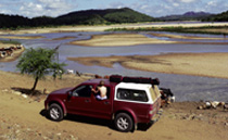
The trip left 10-year-old Daniel and me with a huge number of images, experiences and ideas to digest and, apart from blowing the air-filter in Chimoio, the wonderful Isuzu 300TDi LX Double Cab had hardly required me to open the bonnet. For once my fingernails remained free of oil and grease.
TRAVEL PLANNER
Contacts
Tete
Motel Tete: +258 252 22345/6, fax 22347.
Guesthouse: William +258 822 591410 or Nadia 825 888570.
Gorongosa
Mountain and National Park: www.gorongosa.net. Chalets must be booked well in advance, but there is plenty of camping space.
Chimoio
Pink Papaya Backpackers: Helen Large +258 825 557310; [email protected]; http://pinkpapaya.atspace.com
Mutare
Ann Bruce: +263 206 569.
Rob +263 (39) 761766; [email protected]. www.innsofzimbabwe.co.zw
Smart Tent (SA importer of Oztents): 011 884-6535; 084 513-3340; www.smartent.co.za; [email protected]
TRAVEL TIPS
• South Africans do not need a visa to enter Zimbabwe or Mozambique, and note that Mozambican visas and insurance are not issued at the Mecumbura border.
• Don’t try this route without a very reliable and capable 4×4.
• Avoid the December to April period of intense heat and heavy rain, and if going to Monte Muambe from April to August, protect your radiator from grass seed and remember to clean the grass and seed from the underside of your vehicle to avoid fires.
• Carry enough fuel to cover 1000km.
• Take out an insurance policy that covers emergency medical evacuation and repatriation, and consult a doctor regarding which anti-malarial pills will suit you best.
• Carry 50 litres (per family of four) of drinking water and refill your containers in villages that have a sealed well fitted with a hand-pump.
• Buy an mCel Giro starter pack for MT50 (R15) for your cellphone. We got reception in and around Songo, Tete, Moatize, Changara, Gorongosa (including the park) and from Inchope to Machipanda. It is almost impossible to buy a SIM card in Zimbabwe. Also visit www.mozguide.com.