There you are in Cape Town on business, with a day or two to spare. Instead of moping in your hotel room, or hanging around the very expensive Waterfront shops, why not grab a car and a map and explore for a day? Here are some suggestions
Text: Charles King
Photography: Melanie Cleary
It was a moment of enlightenment on the flight to Cape Town that transformed a potentially humdrum business trip into a magnificent journey without a destination.
High above Kimberley, looking at a gap in the clouds, I promised myself no more lounging listlessly in hotel foyers, Waterfront boutiques, or Kloof Street coffee shops. Life was way too short for that.
So the plan was to head to the Overberg, not stopping until I got to the southern-most tip of Africa.
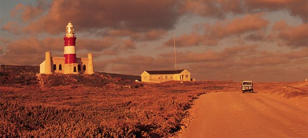
Hardly more than 24 hours later the abnormally thick, rough-hewed, white-washed walls of the Cape Agulhas lighthouse were all that separated me and a polite, petite waitress from the vicious and elephant-grey sky that weighed down heavily on the wind- and rain-lashed Cape Agulhas.
Struisbaai was already swallowed up by the storm’s darkness, and now it was raging against this remote but still working lighthouse, built in 1848 on the southernmost tip of Africa.
These are dangerous waters. More than 120 ships, including the HMS Arniston, have been destroyed along this coastline – also known as the “graveyard of ships” – in terrifying maelstroms of wild seas, howling winds and treacherous undercurrents.
“That’s why the Shipwreck Museum in Bredasdorp is definitely worth a visit,” said a well-weathered middle-aged man as I filled up the Mitsubishi Outlander at what appeared to be Struisbaai’s only filling station.
It was another of those seemingly disjointed “sound bite” conversations that one has with strangers along the road, but that all succinctly piece together afterwards to make up your trip.
L’Agulhas is where the Atlantic and Indian oceans meet, not off Cape Point as many people still believe, but at latitude 34 degrees 49’58” south and longitude 20 degrees 00’12” east, a mere 9797km south of London.
Because you have to travel through the fishing village of Struisbaai to get to Agulhas, make a point of stopping at the quaint Hotagterklip fisherman’s cottages (at the entrance to the village) which have been declared a national monument, along with the thatched church. It’ll give you an idea of how hard life was here for the original fishing folk before this was all on the map, so to speak.
With one of the longest pristine coastlines in the southern hemisphere, stretching for almost 14km, this is undoubtedly fishing territory. Struisbaai harbour, particularly photogenic at dusk or just after a storm, is the centre of the boating and fishing operations.
The Overberg, from the perspective of the scenic route I took from Cape Town that morning, officially starts at Gordon’s Bay. Inhabited since the 17th century by pioneering stock, this region begins as you climb Sir Lowry’s Pass. It is bordered inland by the Sonderend and Langeberg Mountains and by the coastline in the south, all the way up to Cape Infanta and Witsand at the mouth of the Breede River. It includes Barrydale on its very northern edge, reached via the Tradouw Pass from the N2 beyond Swellendam.
It’s filled with alternative people who are passionate about their corner of the world, where the enduring impression is of richness in colour, whatever the season. There is an exceptional quality of light that turns grass emerald green in the rainy winter, while in spring the wildflowers and wheat fields shimmer as if fragments of your imagination.
Kogel Bay, between Gordon’s Bay and Rooiels, forms part of the Unesco-designated Kogelberg Biosphere Reserve, which stretches beyond Kleinmond in the east and is home to well over 1600 plant species. It recognises that people – especially the communities in these protected areas – can live in harmony with the environment.
The breathtaking scenery along a magnificent coastal road constantly divides your attention between the rugged mountains and the ocean below, where the moods change frequently and make you wish you were a professional photographer who could somehow capture their beauty.
But back to my companion, the Outlander, which has a highly efficient fuel system quite appropriate to this particular journey. The inlet camshaft has low-speed and high-speed modes, with the change-over occurring at approximately 3500 r/min. At this point the valve lift is changed to suit the higher rotational speed of the engine. It lets in more air, which allows a useful 125 kW to be developed at 6100 r/min. This results in better fuel economy and lower exhaust emissions.
The Outlander has already been awarded a four-star rating for emission levels that are 75% lower than required by Japan’s 2005 emission standards. In addition, it qualifies for a green vehicle tax exemption in its home market by returning fuel consumption that is 5% lower than 2010 efficiency requirements.
Although the vehicle felt unstable at times when it encountered strong, blustering crosswinds along the cliff road between Gordon’s Bay and Betty’s Bay, I was soon able to gain my confidence and settle down in a car that reacted instantly when I put my foot down.
Intent on leaving the weekend travel rabble behind – all of them seemed to be heading for Hermanus – I regretfully passed Rooiels, Pringle Bay, Hangklip, Betty’s Bay, Kleinmond, Hawston, Vermont, Onrus and Sandbaai, but making mental notes to explore them next time.
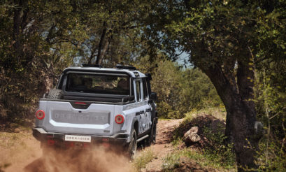
The opportunity to slide into 4×4 mode only came after Gansbaai and Kleinbaai. Because it is an urban 4×4, and because it is more fuel-efficient to drive via just two wheels on dry tarmac, a dial selector on the centre console enables the driver to choose between two-wheel-drive mode, four-wheel-drive auto mode (with the system dispatching torque to the rear only when needed) and a fourwheel- drive “lock” mode, in which the torque is fixed in a 50:50 ratio.
The vehicle handled the potholes and awful road conditions (due to construction) between the Die Dam and the Voëlsvlei and Soetendalsvlei roads fantastically well, and I quickly learnt that I could stop flinching whenever an unexpected pothole appeared.
The rain was still lashing down the following morning when I faced the interior road back to Cape Town. I did not get to see Napier, Springerskuil and Caledon as they flashed by unexplored in-between the wiper blades. Nor did I experience the exhilaration of cresting Sir Lowry’s Pass in the full light and glory of the day.
Yet, from every journey other journeys are born, so I’m looking forward to my next business trip, and another visit to the pristine beaches and turquoise waters of Arniston, among others…
- Mitsubishi Outlander 2.4i GLS Auto 4×4 – R299 900. www.mitsubishi.co.za