into Namibia
SYNCRONISE YOUR VWs
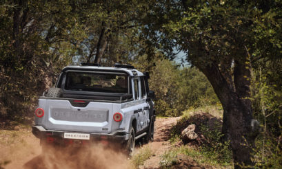
Who needs a full-blown 4×4?
Once a year there comes a moment when you drop pen and pencil and start to visualise the sandy tracks of the outdoors. You hear the sound of the bushveld, and see a crackling fire and the stars above, seemingly within touching distance. And then you make it happen
Text and photographs: Lothar Frohlich
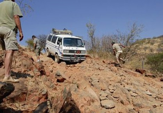
Volkswagen’s Syncro bus, with its raised ride height, viscous coupling that transfers power to the front wheels when the rear ones slip, short-ratio first “donkey” gear and of course all the space the Microbus offers, still has a loyal following in South Africa.
And on many occasions these enthusiasts get together and tackle a trip that owners of pukka 4x4s would hesitate to do. A throw of the dice singled out Namibia, with sandy Khaudom and the rough terrain of the Van Zyl’s Pass deciding this year’s final destination.
Shortly after crossing into Namibia at the Muhembo border post, for our first visit to the country, the convoy was stopped at a veterinary roadblock. Our fridges were emptied, and after 11/2 hours of trying to persuade the authorities that the meat we carried was vacuum-packed by Woolworths in South Africa, we were finally let off the hook. But not without a suggested donation of some meat packets for the local community…
Our group of four VW Syncros and one Toyota Fortuner entered the sandy tracks to Khaudom at Ndonga, between longitude E020 and E021, close to the most southern end of the Caprivi Strip.
The first 60km was extremely sandy, keeping our convoy of five vehicles in first gear. As if in a movie, the winter colours of the mopane forests and the yellow grass lining the white sandy tracks passed by in slow motion.
A lunch stop under a shady buffalo thorn tree was most welcome before we made our way through to the Khaudom Camp, situated on a hill. The camps are very basic – a tap and a concrete slab to make a fire on are about all you get. Our better halves decided this level of luxury deserved only one night’s stay.
We expected to see more wildlife, although the untouched wilderness and open plains with abundant birdlife will always be remembered. According to the game rangers, the months of September and October are usually the best to see large herds of elephants.
We exited Khaudom at Sikereti and headed northwest to the Etosha Pan. The eastern side of the pan near the Namutoni gate was under water, a rare sight that attracted many animal and bird species.
We had to make camp at a lodge outside the reserve as every cottage and campsite was fully booked. Anyway, our intention was to spend more time on the banks of the Kunene River, Van Zyl’s Pass, Purros and the dry riverbeds of the Hoarusib and Hoanib.
For this reason, we exited the pan at Namutoni after a two-day visit, then headed north to Ruacana where we filled up our cars and spare tanks to the brim, taking between 180 and 200 litres of fuel per car for the distance ahead.
It was a tiring day, driving hundreds of kilometres on tar, and we were all looking forward to our planned overnight stop at Hippo Pools on the banks of the rapidly flowing Kunene River.
At daybreak our convoy headed along the Kunene towards Otjimhapa. The gravel road had been widened and new developments along this route are in progress.
But is Namibia pushing progress too far?
Ten years ago, the Epupa Falls had the magic touch of total tranquillity. Amongst the clusters of makalani palms you could relax and listen to the thunder of the falls.
All this has disappeared in a massive development to attract more and more paying tourists. Along the river, sections have been fenced in by different tour operators to accommodate as many overlander groups as possible.
A souvenir shop, a bar with music blaring into the early hours, a lodge, a police station and communication masts are the new invaders. The falls have fallen victim to a money-grabbing industry. What will be next? Fast-food kiosks, or perhaps a casino?
The small stony hill from where you have a view over the entire falls now has a price tag of 10 Namibian dollars per person for taking a shot with your camera.
One kilometre from the falls, on our way out to Okangwati for a visit to a small Himba settlement, we were stopped by the police and fined R300 for not wearing seatbelts. Why not just a friendly warning? Our tour guide who directed us to the nearby Himba village (later we learned that it was his own family) raked in a cool R1000 from our group of eight, as well as a bag of mealie meal. Unfortunately only the mealie meal made in into the hands of the villagers.
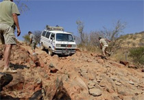
The total length of the Van Zyl’s Pass is approximately 42km. We started the descent around lunchtime and arrived at the bottom during the afternoon of the following day.
The terrain is simply breathtaking. You cannot describe the colours of the rugged mountains and valleys to someone who hasn’t travelled the pass. Van Zyl’s holds some extremely difficult sections, which are indicated on the GPS. The going was not to be dictated by speed or time, but rather by a sense of safety and respect for the environment.
Our girls chose to walk most of the rocky declines, rather than leave teeth marks in the dashboard. Extreme weather conditions a few months earlier made the going even more difficult, and badly rutted sections had to be rebuilt by hand.
Our overnight stop in one of the many valleys under a large Ana tree on the side of a wide riverbank was just what the doctor ordered. A cold beer and wors sizzling over the fire made everyone feel relaxed.
The next morning misty clouds dominated the landscape. They lifted and evaporated rapidly and the surrounding hills showed their true colours once more as temperatures climbed to their normal level. The stunning views over the Marienfluss Valley, surrounded by the Hartmanns and Otjihipa Mountain Ranges, reminded us how privileged we were to share this moment of tranquillity.
Passing a few more difficult sections of the pass we finally made it to the bottom, where, according to custom, you write your name on a flat piece of stone and place it under a nearby tree, mainly for your own pride and sense of achievement, but also for others to read like a visitors’ book.
As I stood there, I wondered if the bright yellow grass of the Marienfluss-Tal would ever change to green during the rainy season? The valley, its people, the community campsite and Camp Syncro on the banks of the Kunene have kept their old welcoming style. We were very impressed by the unspoilt splendour of this most northern section of the Kaokoland.
The far end of the Himba Community Campsite on the Kunene River, with a view across the majestic mountain ranges of Angola, offered us complete privacy for a quick refreshing dip in the shallow waters of the river.